Oman, Yemen on alert for strengthening tropical cyclone Mekunu
The cyclonic circulation in the Arabian Sea had intensified into a well-marked low-pressure area yesterday. Skymet had forecast that the weather system is expected to intensify rapidly in the Arabian Sea and rightly so, it did intensify into a depression during the evening hours. Thereafter, the system underwent another express intensification becoming a deep depression during the late-night hours.
In an overnight intensification mode, now the system has concentrated into a cyclonic storm Mekunu.
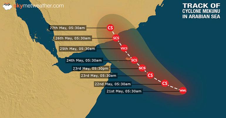
Presently, Mekunu is centred at Latitude 9.1°N and Longitude 57.3°E and is located 560 km SE of Socotra Islands, 970 km SSE of Salalah in Oman and 1350 km South of Masirah Island. The system has moved in a west-northwest direction at a speed of 12 kilometer per hour with the wind speed of 70 kmph gusting up to 90 kmph.
The cyclonic storm is expected to intensify further into a severe cyclonic storm on May 24, which is equivalent to a Cat 1 hurricane wherein the wind speed will be at 125 kmph. Subsequently, it will also intensify into a very severe cyclonic storm on May 25, which will be equivalent to a Cat 2 hurricane with the wind speed of 170 kmph.
The convective bands in the cloud configuration suggest a very well marked low level cyclonic circulation. The environmental analysis indicate strong pole-ward and equator-ward flow, suggesting the power of the system and its likely intensification.
The sea surface temperatures are very warm at 31 and 32 degrees Celsius and the vertical wind sheer is light to moderate which is providing complete support for further intensification. The steering current of the cyclone is suggesting its initial movement which is west northwestward then going northwestward finally going north-northwestward.
The system is expected to strike North Yemen and South Oman as a severe cyclonic storm between morning and evening hours of May 26. The system will be at its peak intensity before the landfall and is likely to make landfall near Salalah in Oman. Thereafter, the system will possibly weaken before making a landfall as a Cat 1 storm. The weakening of the storm will occur due to the terrain interaction and atmospheric entrainment.
As the cyclone is a very powerful one, the regions of Oman and Yemen will be severely affected with flooding rainfall, high velocity winds which may cause flooding in some regions May 26 onward.
This is the second cyclonic storm this season formed in quick succession in the Arabian Sea with the first one being Sagar which had formed on May 17. Mekunu is also following a similar track as of Sagar. This is quite a rare occurrence wherein two cyclones which have formed in the same region following a similar track in less than a week’s interval.
Meanwhile, there is poor consensus as far as the track of the cyclone is concerned. While NCEP is suggesting the landfall close to Salalah, the European and Ensemble models differ in the view.
Share This Post